Resources
This page contains some key resources on walking and cycling, including an archive of the documents produced by the Australian Bicycle Council.
| Date Added | |||
|---|---|---|---|
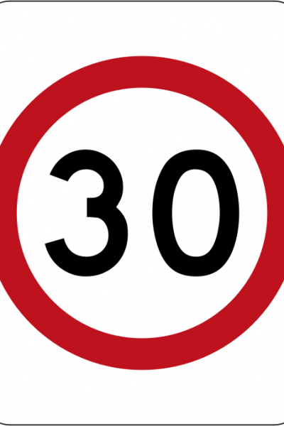 |
Safer Speeds Case Study - Fitzroy & Collingwood, Victoria STREET NAME: Treatment area located between Alexandra Parade (north), Hoddle Street (east), Johnston Street (south) and Nicholson Street (west) SUBURB: Fitzroy and Collingwood MUNICIPALITY: City of Yarra, Melbourne STATE & COUNTRY: Victoria, Australia SPEED REDUCTION: From 40 km/h to 30 km/h DATE IMPLEMENTED: January 2020 (trial start October 2018) SCHEME INCLUDED:
COST: Not available ADDITIONAL INFORMATION:
Observations of pedestrian and cyclist activity were undertaken at a limited number of locations within the treatment and non-treatment areas during three days before the trial implementation and three days at 12 months into the trial. The small number of locations and survey days limits the ability for general conclusions. The data shows a 12.7% drop in pedestrian activity (largely driven by a single site) and a 27.8% increase in cycling activity. LESSONS LEARNED: For some members of the community there was confusion about how the pedestrian priority at the crossings worked, how to determine when to enter and how to exit the roundabout. There are feelings of frustration caused by inconvenience to the driving experience which are perceived to be caused by the Wombat Crossings. Intercept surveys at the Wombat Crossings found people using them thought they created a more convenient walking experience however there was still concern about understanding how the crossings worked and the expectations of people walking and people driving. Information about the benefits of the crossings and the expectations of all road users would assist the community to understand the role they play in creating a pedestrian priority city centre. |
06/10/2022 | |
|
Safer Speeds Case Studies - Gold Coast, Queensland City of Gold Coast LOCATION: Cavill Avenue/Orchid Avenue, Surfers Paradise SPEED REDUCTION: Various – some 50 km/h to 40km/h, 50km/h to 30km/h and 40km/h to 30km/h MUNICIPALITY: City of Gold Coast STATE & COUNTRY: Queensland, Australia SCHEME INCLUDED:
DATE IMPLEMENTED: Various COST: Noted as low-cost initiative in the Gold Coast Road Safety Plan 2021-2026 ADDITIONAL INFO: General support and now going back to some 50km/h to 40km/h zones and undertaking further reviews to reduce to 30km/h LESSONS LEARNED:
|
19/07/2022 | View |
 |
Cycling Standards and Guidance Waka Kotahi NZ Transport Agency Cycling network guidance – planning and design (CNG) framework aims to promote a consistent, best-practice approach to cycling network and route planning throughout New Zealand. |
18/08/2021 | View |
 |
Cycle Route Directional Signage Example Department of Infrastructure, Energy and Resources An example of the process that can be used to map and plan the direction signs required to navigate along a cycle route. The example used is the Battery Point section of the Sandy Bay to Hobart and return route. |
30/07/2021 | View |
 |
St Kilda Road Bike Lanes Department of Transport, Victoria St Kilda Road will soon be safer for everyone with new bike lanes to be built to separate drivers and cyclists. |
16/07/2021 | View |
|
Safe Active Streets Program Department of Transport, WA An innovative program designed to make streets, friendlier and safer for all users including people in cars and those riding bikes and walking. |
06/07/2021 | View |